
Description
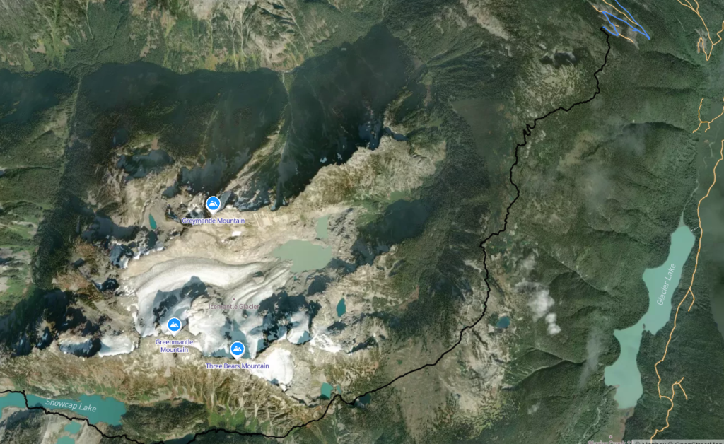
Snowcap Lakes and Mount Pitt are located in a very remote and seldom-visited part of Garibaldi Provincial Park. The primary objective of this trip is to reach and explore Snowcap Lakes. If weather, terrain, glacier conditions, group condition, and timing are favourable, we will also attempt Mount Pitt.
This trip is partly inspired by Ryan’s 2025 attempt to Mount Pitt:
Ryan’s trip report – “Jaunt to Mt. Pitt: 72 Hours of Hot Sloggin’”
https://ubc-voc.com/trip-reports/jaunt-to-mt-pitt-72-hours-of-hot-sloggin-25424/
However, we will use a different route, approaching Mount Pitt via Snowcap Lakes, which may provide an easier approach.
I have also obtained a GPX track and route information from another person who successfully climbed Mount Pitt as a two-day trip last September. Our tentative route will largely follow that track.
This is an exploratory, mostly off-trail trip involving substantial bushwhacking, obscure route-finding, steep side-hilling, long days with overnight packs, Class 3/4 scrambling, loose alpine terrain, exposure, and a short section of glacier travel.
This is not a beginner trip. Participants will be pre-screened.
Rough Trip Stats
Day 1, depending on where we camp
- approximately 16–24 km
- approximately 1,000–1,600 m elevation gain
- substantial off-trail travel and bushwhacking
Mount Pitt day
- approximately 20 km round trip
- approximately 1,300 m total elevation gain
- Class 3/4 scrambling
- approximately 500 m of glacier travel
Distances and elevation figures are approximate. Actual travel may differ considerably because of road access, bushwhacking, route-finding, and conditions.
Itinerary
Day 1 – Vancouver → CH1600 area → Three Bears / Blue Mantle Meadows → Snowcap Lakes
We will leave Vancouver at approximately 5:00 a.m.
The planned driving route is:
Sea-to-Sky Highway → Highway 99 → Pemberton → In-SHUCK-ch FSR → West Lillooet Road → CH1000 → CH1600
The drive is expected to take approximately six hours.
How far we can drive will depend on FSR conditions. We may need to park around the 900 m elevation level or potentially lower.
From the vehicle, we will travel off-trail toward the meadows between Three Bears Mountain and Blue Mantle Mountain.
If progress is slower than expected, we can camp in the meadows. This would make Day 1 approximately:
- 16 km
- 1,000–1,400 m elevation gain
If progress and conditions are good, we will continue toward Snowcap Lakes. The route descends into the valley and includes a more difficult bushwhacking section toward Cutoff Lake. Travel should become easier after Cutoff Lake.
Reaching Snowcap Lakes on Day 1 would make the day approximately:
- 24 km
- 1,600 m elevation gain
Day 2 – Mount Pitt Attempt
If we reach Snowcap Lakes on Day 1 and conditions are favourable, we will attempt Mount Pitt.
Based on previous trip information, the route involves travelling along Rollercoaster Ridge, with sections of approximately Class 3/4 scrambling. The final summit pyramid is reportedly very loose.
The route also involves approximately 500 m of glacier travel.
Approximate day:
- 20 km round trip
- 1,300 m total elevation gain
There is no requirement to summit Mount Pitt.
No rappelling or technical rock climbing is planned. We are also not planning to undertake roped glacier travel. If we encounter terrain where continuing would reasonably require a rope, rappel, technical protection, or more serious glacier travel, we will turn around or change the objective.
If timing permits, we may stay on the ridge above Snowcap Lakes after returning from the Mount Pitt attempt to enjoy the sunset.
Day 3 – Flexible / Additional Objective
Day 3 is deliberately flexible.
Depending on weather, group condition, timing, and the outcome of Day 2, possibilities include:
- exploring the Snowcap Lakes area;
- attempting another nearby objective such as Rain God Mountain;
- having a recovery/rest day; or
- beginning our return.
Any additional summit is optional.
Day 4 – Exit
Return to the vehicle, most likely following our approach route, and drive back to Vancouver.
Because this is an exploratory trip, the actual itinerary may change substantially in the field.
Required Experience
Participants should have significant previous backcountry experience and be comfortable operating with substantial independence in remote terrain.
Participants intending to attempt Mount Pitt should have:
- experience with long and strenuous hiking/backpacking days;
- experience carrying an overnight pack for multiple days;
- substantial off-trail hiking experience;
- experience with bushwhacking and obscure route-finding;
- ability to navigate using GPS/offline maps and participate in navigation decisions;
- experience travelling on steep slopes and side-hilling;
- confidence on exposed Class 3 scrambling;
- some experience with Class 4 scrambling or comparable exposed alpine terrain;
- experience travelling on loose alpine rock;
- basic glacier-travel experience;
- experience using crampons and an ice axe; and
- fitness for consecutive long days with approximately 1,000–1,600 m of elevation gain while carrying an overnight pack.
This should not be your first Class 3/4 scramble, first glacier, first off-trail trip, or first strenuous multi-day backpacking trip.
Participants should be sufficiently experienced to contribute actively to route-finding, terrain assessment, and group decision-making rather than relying entirely on the organizer.
When signing up, please tell me about 2–4 recent comparable trips, particularly trips involving:
- multi-day backcountry travel;
- difficult off-trail navigation or bushwhacking;
- Class 3/4 scrambling;
- glacier travel; and/or
- long days with substantial elevation gain.
I will pre-screen participants based on relevant experience.
It is also fine to join primarily for Snowcap Lakes and remain around the lakes or other easier terrain without attempting Mount Pitt or other Class 3/4 objectives. Please mention this when signing up so we can make sure the group plan works.
Required Items
Normal equipment for a remote four-day alpine backpacking trip, including:
- backpack and overnight camping equipment;
- sleeping bag and sleeping pad appropriate for alpine conditions;
- sufficient food for four days plus emergency food;
- appropriate hiking/mountaineering footwear;
- waterproof shell;
- warm insulating layers;
- gloves and warm hat;
- helmet for participants attempting the scrambling objectives;
- ice axe for participants travelling on snow/glacier terrain;
- crampons compatible with your footwear;
- headlamp with sufficient battery capacity;
- offline navigation capability with downloaded maps/GPX;
- personal first-aid supplies;
- sun protection;
- water capacity and water-treatment system;
- the 10 Essentials;
- bear spray, carried somewhere readily accessible;
- bear-resistant food storage or an appropriate group food-storage system; and
- emergency clothing/equipment appropriate for an unexpected delay or night out.
We will coordinate group equipment and food storage before departure.
Recommended Items
- trekking poles;
- gaiters;
- lightweight camp shoes;
- satellite communicator such as an inReach or equivalent;
- power bank;
- bug protection;
- sunglasses suitable for snow/glacier travel;
- spare socks and gloves;
- bear-spray holster; and
- personal repair/blister kit.
A satellite communicator will be carried by the group, although having more than one is preferable.
Possible Hazards
This is a remote and exploratory trip. Possible hazards include, but are not limited to:
Remoteness / Communication / Rescue
- little or no cellular coverage;
- delayed rescue or evacuation;
- limited nearby assistance.
Route-Finding / Off-Trail Travel
- becoming lost or separated from the group;
- unexpectedly difficult terrain;
- cliff bands or terrain traps;
- substantial bushwhacking;
- slow travel through dense vegetation;
- hidden holes, unstable footing, and steep vegetated slopes.
Steep and Exposed Terrain
- steep slopes and side-hilling;
- slips, trips, and falls;
- exposure and cliffs;
- loose footing;
- rockfall;
- serious injury from a fall.
Class 3/4 Scrambling and Loose Rock
- exposed scrambling;
- loose alpine rock;
- potentially unstable terrain on Rollercoaster Ridge and the Mount Pitt summit pyramid.
No technical climbing or rappelling is planned.
Glacier / Snow / Ice
- hard snow or ice;
- slips and uncontrolled falls;
- crevasses;
- weak snow bridges;
- changing glacier conditions;
- poor visibility.
We will not continue onto glacier terrain that we consider inappropriate for unroped travel.
Wildlife
This is wildlife habitat, and possible encounters include:
- black bears and grizzly bears;
- cougars;
- mountain goats, deer, and other wildlife;
- rodents or smaller animals attracted to food or scented items.
Bear spray and appropriate food storage are required. Food, garbage, toiletries, and other scented items must be securely stored away from sleeping areas.
Weather
Possible conditions include:
- rain;
- high winds;
- cold temperatures;
- poor visibility;
- thunderstorms;
- intense sun or heat;
- snow.
Fatigue / Long Days
- consecutive long days carrying overnight packs;
- possible travel after dark;
- fatigue affecting route-finding, balance, and decision-making.
FSR / Vehicle Access
- rough forest service roads;
- washouts;
- fallen trees;
- vehicle damage;
- getting stuck;
- inability to reach the intended parking location.
A high-clearance 4×4 SUV or truck will likely be required.
Trip Philosophy / Turnaround Decisions
Snowcap Lakes are the primary objective. Mount Pitt is secondary.
This is an exploratory trip rather than a summit-at-all-costs trip.
We may turn around, change campsites, or modify the objective because of:
- glacier or snow conditions;
- terrain more technical than expected;
- scrambling beyond the group’s comfort level;
- deteriorating weather;
- insufficient daylight;
- route-finding difficulties;
- fatigue; or
- any other condition that makes continuing unreasonable.
Distances, campsites, objectives, and turnaround points are therefore flexible.
The goal is to safely explore a spectacular and seldom-visited part of Garibaldi Provincial Park.
Transportation / Carpool
Access will likely require a high-clearance 4×4 SUV or truck.
I currently do not have an appropriate vehicle. If a participant has a suitable vehicle and is comfortable driving it on rough FSRs, that would be very helpful. Otherwise I will investigate renting an appropriate vehicle.
Final transportation arrangements and cost sharing will be organized once the participant list is confirmed.
Route References
Ryan’s 2025 VOC trip report:
Jaunt to Mt. Pitt: 72 Hours of Hot Sloggin’
https://ubc-voc.com/trip-reports/jaunt-to-mt-pitt-72-hours-of-hot-sloggin-25424/
I also have a GPX track and route information from a climber who successfully summited Mount Pitt last September.
Previous reports and tracks are for planning purposes only. Actual road, vegetation, snow, glacier, scrambling, and weather conditions may be different during this trip.
Guest sign-up
Sign-ups are no longer available for this event.